Bury Camp

Bury Camp
data.gov.uk · OGL 3

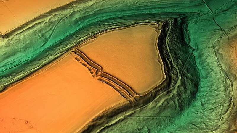
Bury Camp is an Iron Age multivallate hillfort in northwest Wiltshire, England, dating to 500 BC–1 AD. It occupies a triangular promontory of Colerne Down at the southern edge of the Cotswold Hills. The site encloses approximately 9.2 hectares and is defended by a ditch 4 metres wide and up to 1 metre deep, with an outer rampart reaching 1.5–2 metres in height on the eastern, northwestern, and southwestern sides[1][2].

TypeFortress/citadel
Period500 BC - 1 AD
CountryEngland
Coordinates51.4648° N, 2.2633° W

Related resources

More sites in England

Nettleton, Wiltshire · Lugbury Long Barrow · Solsbury Hill · Bathampton Down · St Laurence School - Roman Villa · Little Sodbury · Roman Baths, Bath · Aquae Sulis · Midford Castle · Stoney Littleton Long Barrow · Uley · Uley Bury · Stantonbury Camp · Bratton Castle · Tunley Camp · Uley Long Barrow · Kingsdown Camp · Nympsfield Long Barrow · Tedbury Camp · Longstone of Minchinhampton · Wadbury Camp · Cley Hill · Woodchester Roman Villa · Windmill Tump

All sites in England

Was this page useful?

Keep exploring

Every site on this page sits on the globe, and the people who research them are on the Discord.

3D Globe · Sites by country · Story Archive · Research Library · Weekly Journal · Search