
 Peru
PeruThe Petroglyphs of Pusharo constitute a unique and extensive ancient rock art archaeological site in southeastern Peru's Manú National Park, an expanse of rain forest that still contains unexplored and little known areas [1]. A smattering of adventurers began to arrive at the site in the 1950s, and in 1969 it was visited by the Peruvian physician Dr. Carlos Neuenschwander Landa [1]. In 1991 the party of North American explorer Gregory Deyermenjian arrived at Pusharo [1]. The site has since been visited and studied by rock art scholar Rainer Hostnig [1]. The site is made up of an array of deeply incised rock carvings that cover up to a height of 9 feet, a perpendicular rock face that is over 100 feet long and 75 feet high [1]. Its location is on the south shore of the Río Palatoa (designated on some maps at this location as the Porotoa, and known by others as the Palatoa Chico) [1]. The petroglyphs contain elements such as heart-shaped faces, some with double borders, spirals, zigzags, suns, "curlicue Xs" and others that defy verbal description [1].
Text: Wikipedia – 'Pusharo' (revision of 2026-07-03), CC BY-SA 4.0 · sentences selected and shortened by an AI system · source →Pusharo
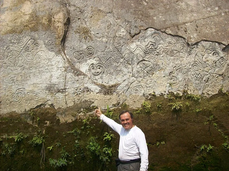
Also known as: Petroglifi di Pusharo, petroglifos de Pusharo, Pétroglyphes de Pusharo, Pusharu
| Type | Petroglyphs |
|---|---|
| Period | 3000 - 1500 BC |
| Country | Peru |
| Coordinates | 12.5841° S, 71.4860° W |