

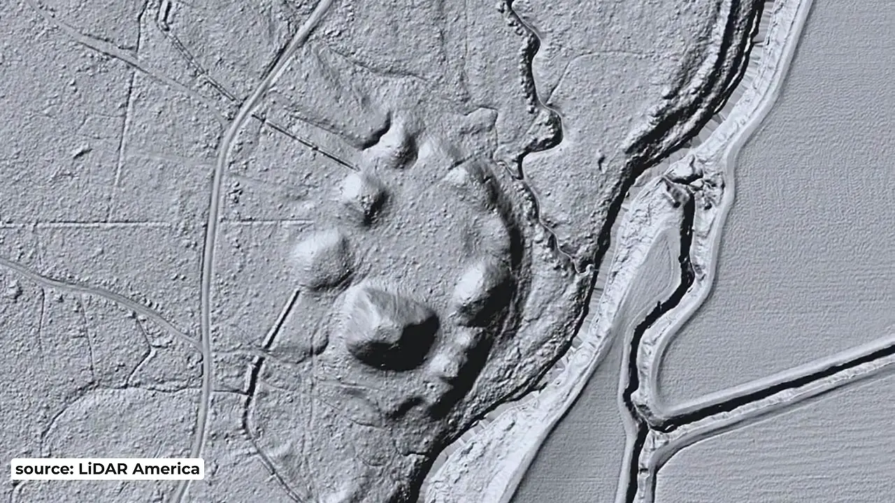
LiDAR imagery reveals an oval plaza ringed by nine earthen pyramids at Raffman Mounds in Madison Parish, Louisiana — where ordinary aerial photos show nothing. Mound A, the largest, rises ~39 ft over a 246 by 330 ft base. The plaza was built 1000-1100 AD; the site was abandoned by ~1200 AD. 🔍
Raffman Mounds: LiDAR reveals oval plaza ringed by nine earthen pyramids
 TaiwanRemote Sensing
Key facts
- LiDAR imagery reveals an oval-shaped plaza surrounded by nine earthen pyramids at Raffman Mounds in Madison Parish, Louisiana, where conventional aerial photographs show nothing.
- Mound A is the largest at the site, about 39 ft tall and 246 by 330 ft at its base, roughly two football fields.
- The plaza measures about 300 by 330 ft and was constructed between roughly 1000 and 1100 AD, although the site itself was founded around 700 AD.
- The site was abandoned by about 1200 AD, placing it in the first Mississippian cultural surge that followed Cahokia's decline.
- Raffman Mounds was found in late 1954 and excavated again in the 1990s and the 2000s.
- The presenter notes the oval plaza plan resembles Watson Break, about 65 miles to the west, but Watson Break was built around 3500 BCE, roughly 4,000 years earlier, so a connection is unlikely.
Sources
automated detection of prehistoric conical burial moundsnwmissouri.edu
by MA RILEY · 2009 · Cited by 30 — LiDAR was able to obtain enough last- return points of the ground to produce a shaded relief image of these micro topographic features (Figure ...
USGS Lidar Explorer Mapapps.nationalmap.gov
Click on the map to retrieve information about a lidar project. The availability information is based on the Lidar Point Cloud layer. The USGS Imagery Topo ...
Archaeologists identify ancient North American mounds ...eurekalert.org
LiDAR has been particularly effective at showing the characteristic rises in topography that mark the presence of mounds. The challenge to ...
Archaeologists identify ancient North American mounds ...binghamton.edu
LiDAR has been particularly effective at showing the characteristic rises in topography that mark the presence of mounds. The challenge to ...
Mapping Archaeological Sites Using Airborne Lidar Datarthunen.domains.unf.edu
This example demonstrates the power of lidar and Surfer to create maps of difficult-to-reach archaeological or historical locations. After ...
Was this story useful?
Keep exploring
Every site on this page sits on the globe, and the people who research them are on the Discord.
3D Globe · Sites by country · Story Archive · Research Library · Weekly Journal · Search
AI-generated text · images from the original sources · always verify with the sources.