

Week of September 28: Greece's Record Pushed Back 700,000 Years, Chan Chan's 38-Burial Platform, and More
Coal mining at Megalopolis in Arcadia has pushed Greece's archaeological record back to about 700,000 years with stone tools at Kipparissia 4 and 430,000-year-old wooden digging sticks from Marathousa 1, alongside new uranium-series dating putting the Petralona cranium at a minimum of 286 ± 9 thousand years. At Chan Chan, excavators uncovered a nearly intact 600-year-old walled funerary platform, roughly 17 meters per side, holding at least 38 Chimú burials with gold, metal and shell grave goods. A sandstone lintel inscribed with Ramesses II's royal titles and a reference to restoring a statue of Horus, Lord of Mesen, is the strongest clue yet that Tell Abu Saifi in northern Sinai is ancient Mesen, though specialists call the identification strengthened rather than confirmed. Other findings include 25,000-year-old Indonesian teeth with arecoline indicating the earliest known drug use, newly mapped roads and a 1.2-kilometre trail extending the Mandor network around Machu Picchu, and modelled Indus basin droughts lasting more than 85 years each between 4400 and 3400 years ago.
Coal mining at Megalopolis in Arcadia has pushed Greece’s archaeological record back to about 700,000 years with stone tools at Kipparissia 4 and 430,000-year-old wooden digging sticks from Marathousa 1, alongside new uranium-series dating putting the Petralona cranium at a minimum of 286 ± 9 thousand years. At Chan Chan, excavators uncovered a nearly intact 600-year-old walled funerary platform, roughly 17 meters per side, holding at least 38 Chimú burials with gold, metal and shell grave goods. A sandstone lintel inscribed with Ramesses II’s royal titles and a reference to restoring a statue of Horus, Lord of Mesen, is the strongest clue yet that Tell Abu Saifi in northern Sinai is ancient Mesen, though specialists call the identification strengthened rather than confirmed. Other findings include 25,000-year-old Indonesian teeth with arecoline indicating the earliest known drug use, newly mapped roads and a 1.2-kilometre trail extending the Mandor network around Machu Picchu, and modelled Indus basin droughts lasting more than 85 years each between 4400 and 3400 years ago.
New Excavations & Fieldwork
At Chan Chan, the Chimú capital, reports describe a well-preserved, nearly intact square funerary platform associated with 38 Chimú individuals; BBC and Al Jazeera say “at least 38” [1]. It escaped the looting of elite tombs, though this does not prove every deposit was sealed. The platform and its funerary deposition are broadly placed in the late pre-Columbian period; the platform is about 600 years old, but no dating method or calibrated range is given. The walled structure is nearly 17 meters per side and 5 meters high, with a staircase to the central chamber and two larger side chambers.
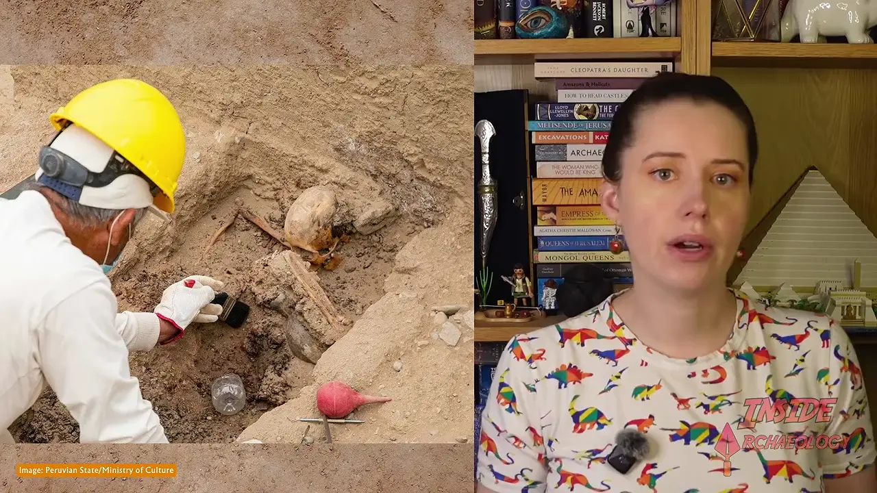
One account places one individual with shell and metal objects in the central chamber; weapons and metal objects in one side chamber, with no count specified; 20 people in the other; and 18 burials elsewhere [V1]. If the categories are mutually exclusive, their total is 39 rather than 38, a discrepancy that remains unresolved. Grave goods included gold or other metal ornaments and shell artifacts; one account lists metal ear ornaments, necklaces, headdresses, carved wooden boxes with metal appliqués, and weapons, but the inventory is not independently corroborated. The deceased are generally interpreted as elite on the basis of context and grave goods, though none is securely identified. Red pigment and one fully extended burial were reported, but the significance of both remains unresolved. The platform fits a broader tradition of walled compounds with ruler-associated funerary platforms, but it does not establish whether the deceased were rulers or retainers.
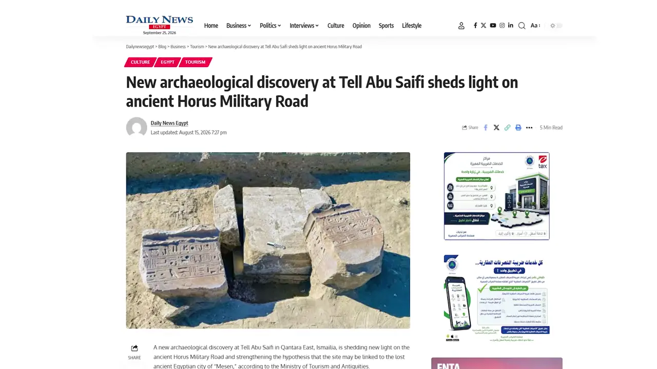
At Tell Abu Saifi, near Qantara East in northern Sinai and along the Ways of Horus, excavators announced in August 2026 the discovery of a sandstone lintel—also described as a broken beam—inscribed on three sides and bearing Ramesses II’s royal titles; one outlet also reported his name [2] [V2]. Its reported reference to restoring a statue of Horus, Lord of Mesen, supplies a textual association with Mesen, but not an explicit civic identification of the settlement; the royal titulary alone is not site-specific. The lintel is therefore the strongest published clue yet to the identification of Tell Abu Saifi as ancient Mesen, or Mesem, although specialists regard the equation as strengthened rather than conclusively confirmed. The association is not wholly new: earlier inscribed blocks reportedly referred to Horus of Mesen, although no text, date, findspot, or publication for those blocks is supplied.
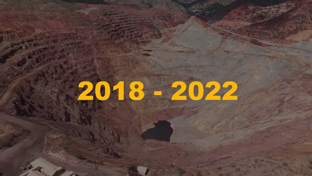
Megalopolis has pushed Greece’s known archaeological record back to about 700,000 years: Kipparissia 4, buried roughly 70 metres below the former ground surface, yielded stone tools associated with giant deer, hippopotamuses, rhinoceroses, elephants, and a macaque tooth, although no human fossils were reported [V3]. This is a Greek chronological record, not a claim to the world’s earliest stone tools, since Spanish sites are older than one million years. The phase identified at five localities between 2018 and 2022—Kipparissia 4, Marathousa 1 and 2, Trioupi 4, and Kyarissi 7—extends from approximately 700,000 to 280,000 years ago. Marathousa 2, dated to roughly 450,000 years ago, included a cut-marked hippopotamus skeleton; Marathousa 1, dated to around 430,000 years ago, produced a cut-marked straight-tusked elephant showing marrow breakage; and Kyarissi 7 is described as Greece’s oldest Middle Paleolithic site. These deep contexts became accessible because open-cast lignite mining associated with local power generation cut through Middle Pleistocene lake mud and other fossiliferous deposits.
The basin has also transformed the history of wooden technology. As of January 2026, artifacts from deposits approximately 430,000 years old were described as the world’s oldest known evidence of handheld wooden tools: a worked alder trunk interpreted as a digging stick, a smaller willow-or-poplar implement, and an alder piece bearing carnivore claw marks [3]. Together, the mines have exposed a long Paleolithic sequence in Arcadia’s central Peloponnese rather than a single isolated discovery.
Artifact Discoveries

Several publications date the sculpture to approximately 11,000 years ago, yet the supplied material does not explain whether that estimate came from stratigraphy, radiocarbon dating, associated material, stylistic comparison, or another method. Popular coverage also presents it as unique or previously unknown, but no excavated comparanda, systematic image corpus, or stylistic analysis are provided to test that assertion. A public discussion characterized the find as significant but underexplored and reported that the presenters planned to follow up with a researcher named Lee; it included no response or findings from Lee [V4]. The evidence therefore supports a reported human-leopard composition, while its riding action, archaeological context, dating basis, and claimed uniqueness remain open questions.
Dating & Chronology
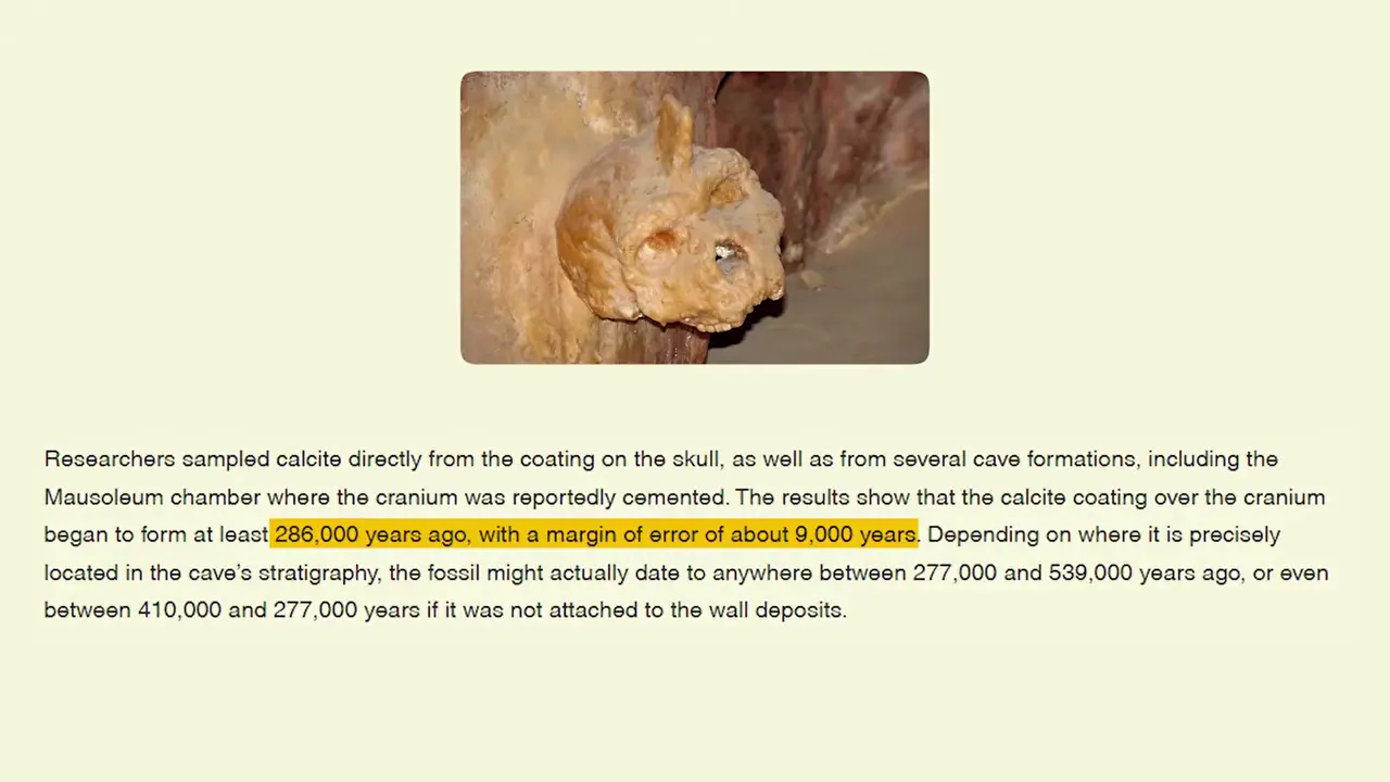
The renewed uranium-series dating study reports a minimum age estimate of 286 ± 9 thousand years for the Petralona cranium. This makes “approximately 300,000 years old” a reasonable rounded summary, but not an exact determination [5] [V5]. Crucially, the estimate was obtained from calcite crust grown directly on the specimen, rather than from unrelated calcite or potentially disturbed cave sediments; additional calcite from the cave’s karst network served as contextual comparisons.
The renewed campaign, resumed in 2019 with the Greek Ministry of Culture, collected comparison samples that could be evaluated against measurements made roughly 45 years earlier [4]. Direct-coating dating also addresses a longstanding disagreement over the skull’s chronology. Earlier results were heterogeneous: the supplied academic material says dating began around 170,000 years ago, while a popular account gives a provisional range of 170,000–700,000 years and attributes the spread to disturbed cave sediments. The fossil tested is the nearly complete cranium discovered in 1960, regarded by the Archaeological Museum of Thessaloniki as one of Europe’s most complete cranial fossils.
Remote Sensing & Technology
The most significant reported discovery is that Mandor’s built environment extends into a connected network of movement and terraces: newly identified roads reach platforms and terraces adjacent to the so-called Mandor Wall, while a separate reported 1.2-kilometre trail heads south from the wall and probably connects with previously identified archaeological enclosures [V6]. Together, these physical relationships suggest that Mandor was not an isolated monumental complex but part of a wider circulation-and-terrace landscape surrounding Machu Picchu.

The location of the wall should be stated cautiously. A secondary video places the Mandor Wall east of Machu Picchu and frames it as part of the wider cultural landscape around the UNESCO World Heritage property, but the supplied academic and news snippets do not independently confirm that orientation [V6]. The newly identified routes also raise questions about territorial control around Machu Picchu; however, the physical connections alone do not demonstrate such control. A commercial travel description gives the linear structure as approximately 1,075 metres long and 2.50 metres wide, but those dimensions apply to the structure rather than the separate trail and lack primary-survey corroboration in the supplied material [6].
Archaeological authorities in Cusco reportedly ordered a targeted investigation of newly identified features at Machu Picchu to determine what the remains are, when they were built, and how best to protect them [V7]. The planned work will combine field surveys with detailed recording, allowing researchers to document the features systematically and examine their form and construction.

Bioarchaeology & Ancient DNA
Approximately 25,000-year-old dental evidence may represent the earliest known drug use, placing areca-nut exposure deep in human prehistory. The finding concerns two early-forager skeletons from Indonesia assigned broad ranges of 25,000–16,000 and 7,600–6,300 years ago, but the available reports do not establish which individual corresponds to each date, groove, or chemical result [V8]. The teeth displayed unusually deep, rounded, hollowed-out grooves, although it is unclear whether every feature was measured identically. Arecoline was reportedly detected in ancient dental tissues, providing biochemical evidence of areca-nut exposure or consumption beyond dental wear alone [8].

Laboratory experiments in which whole areca nuts were soaked in artificial saliva produced broths that activated cloned human receptors in frog egg cells at physiologically effective concentrations. This supports a possible mechanism by which sucking whole nuts could release arecoline, but does not prove that ancient users experienced its effects. Researchers suggest that severe tooth wear may have exposed pulp chambers and caused toothache, with arecoline’s analgesic effect encouraging continued use; this adaptation remains untested. The “earliest” label is also unsettled: other accounts identify roughly 3,500- or 4,000-year-old teeth as the previous direct biochemical benchmark, a discrepancy the supplied material does not resolve [7]. Historical references document areca chewing in Southeast Asia by the sixth century, but they postdate the proposed evidence by millennia and do not independently demonstrate continuity.
A 2025 video summary reports that a three-component model assigns Trypillian individuals approximately 81% “Balkan Copper Age,” 14% “Bulain hunter-gatherer,” and 5% “Caucasus–Lower Volga stream” ancestry [V9]. This 81% estimate is not yet independently verified: the supplied PMC and Kiel excerpts do not publish the percentages, sample descriptions, or modeling details, and the video itself says that this decomposition agrees with a secondary model report. The figure should therefore be understood as a model-derived ancestry component, not a directly measured or fixed ethnic or geographic identity.
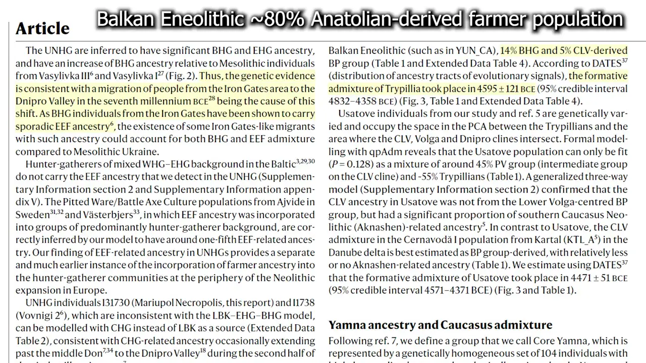
The broader model proposed in the video portrays early Anatolian farming colonists as spreading through the Mediterranean and Balkans with less than 10% mixing with native Europeans. Within that framework, western hunter-gatherers carried only about 15% eastern-hunter-gatherer-related ancestry, while Vinca had roughly 90% Anatolian ancestry; Cucuteni-Trypillia was more admixed but still far from an equal farmer–hunter-gatherer mixture. Independent academic work likewise finds approximately 60–80% Early Neolithic farming ancestry in Cucuteni-Trypillia/CTCC individuals, broadly supporting a major farmer-related component without validating the specific 81% estimate [9]. At Vatya Cave in western Ukraine, the video reports hunter-gatherer-related ancestry inherited from hunter-gatherers farther west rather than local foragers, but the supplied material offers no sample-level or statistical corroboration.
A 2023 study of 288 adults from Atacama-coast funerary sites in northern Chile found that skeletal violence was broadly invariant across a sequence spanning approximately 10,000 BP to AD 1450, but lethality increased substantially during the Formative Period (1000 BC–AD 500); by AD 1000–1450, violence and lethality remained broadly similar to that Formative level [10] [12]. The evidence therefore points to a major rise in lethality by the Formative followed by persistence, not a securely demonstrated continuous escalation between 1000 BC and AD 1450.

Before that shift, a sample of 136 skeletons spanning roughly 10,000–3,000 BP found that 25% had trauma linked to interpersonal violence, generally to the skull or upper body, but only 2% had lethal trauma; a secondary account describes the later change as progressively more lethal through AD 1450, a more specific interpretation that may reflect different temporal resolutions [V10]. A 2021 study of the first horticulturists likewise found trauma compatible with violence in about 21% of adults, with men affected particularly frequently, although it does not provide the corresponding lethal-trauma proportion [11]. The record includes an approximately 2,000-BP Azapa Valley mass grave with lethal perimortem violence involving three adults; Tarapacá 40 documents lethal cranial violence against an adult woman. Population growth did not initiate the violence that had characterized preceding millennia, though it may have increased fatal conflict; resource competition, political organization, and contact with neighboring horticulturalists remain hypotheses rather than demonstrated explanations.
Ancient Art
Serge Kasan has identified apparent narrative sequences in prehistoric rock-art carvings, with one composition bringing together men, boats, and a whale [V11]. This is the central reported discovery: rather than a set of isolated images, the carvings are presented as scenes in which figures and objects participate in an unfolding event. The summary does not establish how secure the connections among the individual elements are, however, so “apparent” remains an important qualification.

In Brief
A 2025 study reconstructs severe, persistent river drought across the Indus basin from roughly 4400 to 3400 years before present, identifying four prolonged dry intervals, each lasting more than 85 years. A later retrospective dates the study’s publication to November 2025 and reports that the longest interval lasted about 164 years [V12], although that precise figure is not independently confirmed in the available primary-paper excerpts. The reconstruction combined lake-sediment and cave-deposit archives with computer-based palaeohydrological simulations to estimate river flow at 17 locations. Near Kot Diji and Ganweriwala, modelled flow was approximately 12% lower than in an earlier comparison period.

Study summaries associate the anomalies with rainfall deficits of up to 20%, reductions in summer and winter rainfall, lake and playa contraction, lower flows, and drying soils. Effects varied spatially: Saurashtra had smaller estimated losses than the hardest-hit Indus sites, especially in earlier intervals. The retrospective places the worst drought after the main urban phase, suggesting it prolonged an existing crisis rather than initiating the move away from urban life, though that placement is not independently confirmed. Earlier proxy work supports monsoon weakening near 4.1 ka, before urban contraction, but does not directly validate the four modelled intervals [13]. Accordingly, reduced water availability is one possible contributor to dispersal and Harappan transformation amid climatic, social, and economic pressures—not a demonstrated sole cause [14]. Crop changes and eastward migration have been reported as responses, but their timing, scale, and drought-specific causation remain unestablished.
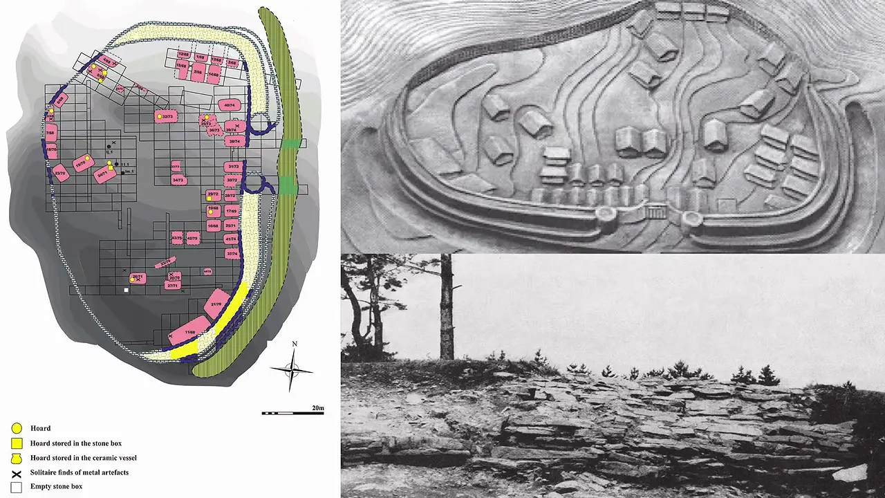
The clearest picture for the Spissky Stvrtok context is of a major transformation of Carpathian settlement during roughly 1600–1200 BC. A warm interval around 2000–1750 BC had favored the growth of tell settlements, but cooling and increased precipitation began around 1500 BC. This shift was followed by renewed warming and substantially reduced precipitation during approximately 1500–1200 BC, broadly overlapping the period of substantial tell abandonment [V13].
A reported 2025 investigation by a Sivas Cumhuriyet University team mapped regular-edged subsurface reflectors at depths of approximately 3–7 m using ground-penetrating radar, including intersections at right angles that form corner-like patterns [V14]. The 538-foot-long (164 m), boat-shaped formation lies about 18 miles (29 km) south of Greater Mount Ararat. Samples from inside reportedly contained about 40% more organic carbon than surrounding soil, while a camera robot recorded organic layers in drilled holes. Core material was reported from as deep as 18 m, and no bedrock was encountered; laboratory analyses remain pending, with results expected in 2027.

The most striking claim about the roughly 2,800-year-old palace at Yeha is that engineers modeled its walls as capable of supporting 16 storeys—but this is a structural estimate, not an observed floor count. Working with the German Archaeological Institute, the engineers represented the walls as rubble-and-clay construction laced with timber and concluded that, under unspecified “worst-case” assumptions, they could bear up to about 16 storeys, approximately twice an earlier eight-storey reconstruction [V15]. No drawing or publication for that earlier reconstruction is supplied, so the “16-storey palace” description remains conditional.
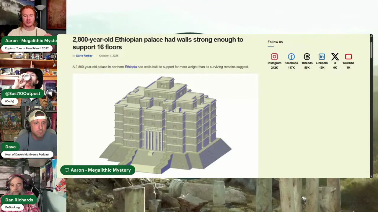
Yeha-specific accounts place the building at about 800 BCE, although they do not report the dating method, calibrated range, or chronological uncertainty [17]. One YouTube-derived summary gives a footprint of approximately 60 by 60 meters on a 6-meter-high podium, with ground-floor walls around 1.9 meters thick and entrance pillars about 30 feet tall. Without an independently corroborated measured plan, section, or excavation record, these figures—and any inference about upper floors—must be treated cautiously. UNESCO describes a multi-storey, timber-framed palace built in wood-stone architecture and calls it the largest known timber-framed building in East Africa and South Arabia [15]. The engineering account instead emphasizes rubble-and-clay walls laced with timber, a discrepancy the supplied excerpts do not resolve. Another report calls Yeha the largest known palace-like structure of the early first millennium BCE in those regions [16]. Both “largest known” designations remain provisional.
Sources
- 600-year-old tomb of pre-Incan Chimu kingdom found in Peru
- Ramesses II inscription may point to Egypt’s lost city of Mesn
- Megalopolis, Greece
- New U-series dates on the Petralona cranium, a key-fossil for …
- New U-series dates on the Petralona cranium, a key fossil in …
- Mandorpampa in Machu Picchu
- Ancient teeth reveal the Ice Age origins of the world’s 4th …
- Ancient teeth reveal humans were getting high …
- Genomes from Verteba cave suggest diversity within … - PMC
- Violence in fishing, hunting, and gathering societies of the Atacama Desert coast: A long-term perspective (10,000 BP—AD 1450)
- Violence among the first horticulturists in the atacama …
- Violence in fishing, hunting, and gathering societies of … - PMC
- Indian winter and summer monsoon strength over the 4.2 ka BP event in foraminifer isotope records from the Indus River delta in the Arabian Sea
- River drought forcing of the Harappan metamorphosis
- The Cultural Heritage of Yeha
- Ancient Ethiopian palace could have stood 16 storeys high, …
- A 2800-Year-Old Palace in Africa May Have Been One of …
Videos
V1. Inside Archaeology — “What Did Archaeologists Find in September 2026?” V2. World of Antiquity — “New Clues to Ancient Mysteries (2026)” V3. Michael Button — “We Just Found Something in Greece That Rewrites History” V4. The Prehistory Guys — “MUD BRICKS: Did Having Rooms Change Everything for Prehistoric People?” V5. Michael Button — “We Just Found Something in Greece That Rewrites History” V6. Luke Caverns — “Major Discoveries at Machu Picchu: LiDAR finds Ruins & Buried Highway” V7. Luke Caverns — “Major Discoveries at Machu Picchu: LiDAR finds Ruins & Buried Highway” V8. Inside Archaeology — “What Did Archaeologists Find in September 2026?” V9. Timeless with Fred Snyder — “Complete Story of Cucuteni-Trypillia” V10. The Historian’s Craft — “The First Wars Were Absolutely Horrifying” V11. The Prehistory Guys — “Did Prehistoric Humans Have a Concept of History?” V12. World of Antiquity — “New Clues to Ancient Mysteries (2026)” V13. The Historian’s Craft — “Europe’s Most Controversial Bronze Age Site….probably, anyway” V14. The Archivist’s Journal — “Did They Actually Just Find Noah’s Ark?” V15. DeDunking — “Hanging with the Boys: Noah’s Ark, UFO’s & Olmec Lycanthropes”
Keep exploring
Every site on this page sits on the globe, and the people who research them are on the Discord.
3D Globe · Sites by country · Story Archive · Research Library · Weekly Journal · Search